Project description

Pow Water Is a branch in the middle reaches of the River Earn River basin. This lowland was once a flood marsh, in the 13th century, an artificial ditch -- Pow Water was excavated here to drain the marsh, Since then, human activities (including grazing and agriculture, deforestation) have begun to colonize and expand in this tributary basin, reducing groundwater levels and biodiversity, and destroying natural habitats. Nowadays, the Pow Water basin has been completely occupied by intensive agriculture, and agricultural production has seriously affected the health of water and soil, and seasonal flooding has become an increasingly serious issue. How to alleviate the existing environmental problems and cope with the future environmental challenges? What will be the future of agriculture? This project does not aim to answer all these questions, but to learn about new alternatives, and explores creative ways of imagining the future.

The project name is cultivating wetness and is the process of increasing the groundwater table, maintaining carbon lock- -and creating important habitat. The project site is focused on the area of the basin most affected by floods and with the most agricultural land coverage, the design challenges the existing land use of the site, it illustrates a possible temporal alternative, in the changeable climate crisis on the basis of temporal external drive, through periodically adjust the land use of the floodplain (from wet grassland to paludiculture), thinking the possibility of the future green transition of rural economy and the possibility of creation of diversified habitat and non-traditional rural landscape.

Target Site as a Testing Ground

The overlaying of the selected clustering information culminates with the confirmation of the area around the middle reach floodplain area of Pow Water as a prime location for exemplary interventions, as a testing ground.

The first main reason for choosing this area is that it is the area most affected by both river flooding and surface flooding within the basin, and large tracts of farmland and pastures on the banks of the river are often completely submerged in the wet season; the second reason is that this area has the most coverage of agricultural land use. The third reason is that the soil composition along the river of this area has basin peat soil content, which is also a critical site potential and driving force that affects project proposals and interventions.

These three characteristics show the target site is, within the entire Pow Water catchment, the area where humans have changed the natural environment the most, and at the same time, human activities are most affected by environmental problems (floods), but there is also an ecological potential (peat soil). These three aspects jointly build the research value of the target site.

Target Territory -- Locating the testing ground expand
Target Territory -- Locating the testing ground
Wetness as an Anchor

In essence, the existing problems of the site seem to be linked to the water as a 'wet' object. In the historical dimension, at the start people dug Pow Water to drain water (wetness), the water table dropped and carbon stored in marshes leaked out. Now, intensive farming has compacted the soil, making it difficult for water (wetness) to infiltrate into the ground, and making it rolls into the river, carrying nutrients that crops fail to absorb. When the water (wetness) comes in strong in winter(winter rainfall), the rivers are full and wetness cannot infiltrate into the soil, so it gathers in lower ground and causes flooding.

These problems are related to the fact that humans can no longer live in balance with 'wetness' after altering and over-interfering with nature. From these aspects, the project begins to design with 'wetness' as an anchor point. The project hopes that our relationship with 'wetness' will move from seeing it as a threat to embracing it, to actively cultivating it. At the same time, this 'wetness' can be in many dimensions - the physical wetting of the land, the 'rewetting' of scarce habitats, and the cultural 'rewetting' of the site.

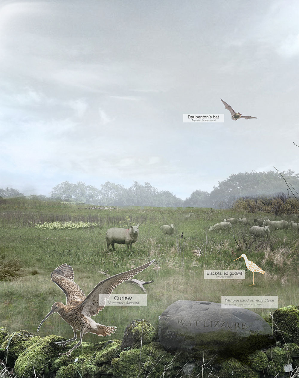
The centrepiece of the practice of cultivating 'wetness' in the dynamic system is the transformation of existing agricultural land in floodplains with compacted, flood-affected ground into a Paludiculture farming system, also a blue carbon ecosystem. It creates desperately needed habitats for many threatened wader birds (e.g. Curlew, Whimbrel, Black-tailed godwit) while producing bioenergy and products from paludi crops can generate more income per hectare for farmers than is currently possible. It also creates a resilient water system that raises the groundwater table and mitigates the effects of flooding.

Overall Dynamic System expand
Overall Dynamic System
Strategies and Patches change

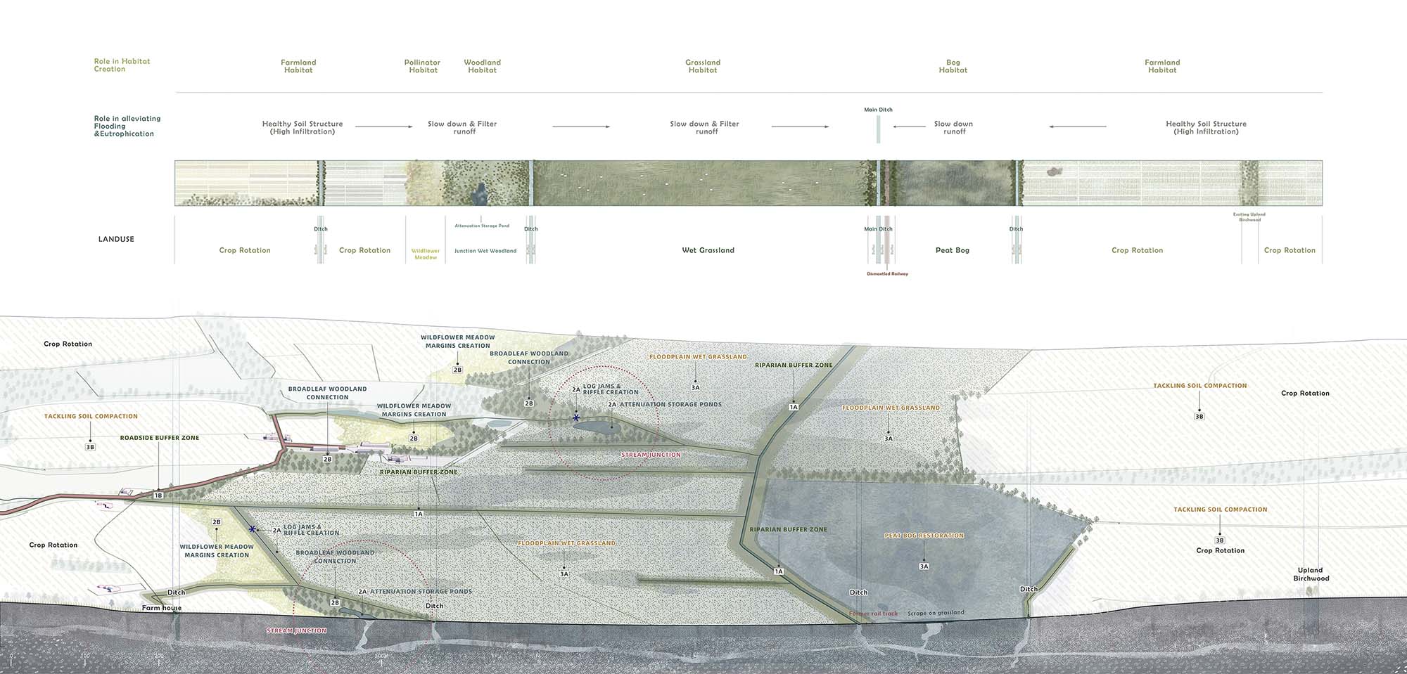
Based on the previous analysis of the target site, the typical patch types of the site have been divided into the patches shown in the figure. 

The plane patches are the junction area of several branches on higher ground, the margins of arable land and woodland outside the floodplain, the margins of arable land and the lower floodplain in the middle of the site. Linear patches are mainly: riparian areas, roadside areas, and dismantled railway lines. The point ones are farm warehouse. The collection of these typical patches together forms the site plan. 

By showing the dynamic change of these prototypes of patches on the site, it is possible to visualise the variation of each patch type on the site clearly.

Strategies and patches change expand
Strategies and patches change
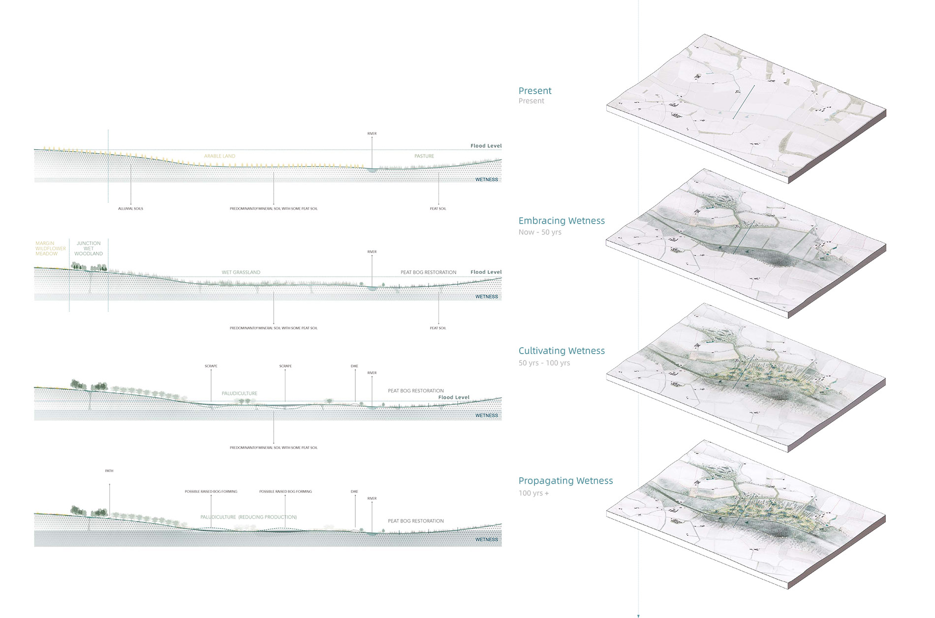
01 I Embracing Wetness

Short-term Strategies (Now-50 years)

The main short-term goal is to alleviate the existing flooding, eutrophication, soil compaction and habitat loss problems, and restore small peat bog on the south bank of the river. 

The theme of this phase is to embrace wetness, which is to rewet the floodplain area and raise the groundwater table by changing it into a wet grassland. In the first 50 years, from now to 2073, it was planned to use natural flood management (SEPA) measures to restore soil, slow and filter surface runoff, and connect the habitat by woodland and flower meadows creation. The floodplain will be rewetted into a wet grassland as a rotation resilient area for grazing in the dry season and planting cover crops in the rainy season.

Section & Landform (in 50yrs) expand
Section & Landform (in 50yrs)
02 I Cultivating Wetness

Mid-term objectives (50 years-100 years)

In 50 years, climate change will lead to increasing extreme weather, reduced space and time suitable for agriculture, and lower agricultural output and profit. The theme of this interim phase is to cultivate wetness, create resilient paludiculture agricultural systems to adapt to complex climate change and introduce new composite energy production to promote regional economic sustainability. 

Creating a mosaic paludiculture system in existing wet grassland areas where peat soil exists, connecting many scrapes through small ditches to form a resilient water system, seasonal high water levels is no longer a threat and will be a source of vitality and stability for this field.

For humans, this wetland farmland will become a Commons, a biomass energy cooperative, promote community participation and generate more income for farmers than existing conditions. In terms of more-than-human, paludiculture areas will collect runoff and use wetland crops to filter nutrients for upper arable land to reduce the risk of flood and water eutrophication. At the same time, this paludiculture area will serve as a blue carbon ecosystem to promote carbon storage and as a habitat for many threatened species, such as wading birds, to improve biodiversity.

Section & Landform (in 100yrs) expand
Section & Landform (in 100yrs)
03 I Propagating Wetness

Long-term objectives (100 years+)

By 100 years, the theme of this stage is propagating wetness, in the cultural, economic, ecological and other aspects. The project plans to turn it into a hybrid area of production, education,tourism,  promoting the interaction of people, ecology and places. 

A major visitor trail will pass through the various biotopes and production areas, evoking thoughts about the relationship between land, water and each other.

At the same time, the paludiculture crops established in the previous phase were used as raw material for the creation of these small thatched infrastructure nodes along the trail, improving the infrastructure for tourism and connecting the productive and residential aspects of the site, bringing people closer to the place and the water.


Master Plan (in 100yrs+) expand
Master Plan (in 100yrs+)
Visualizations of floodplain area change
Student list
open list
close list