Project description

The design aims to establish a post-glacial landscape park in Skeiðarársandur to protect human and more than human from potential glacial outburst flood, developing ecological value of the region and creating a memorial landscape along the floodplain for future cultural development.

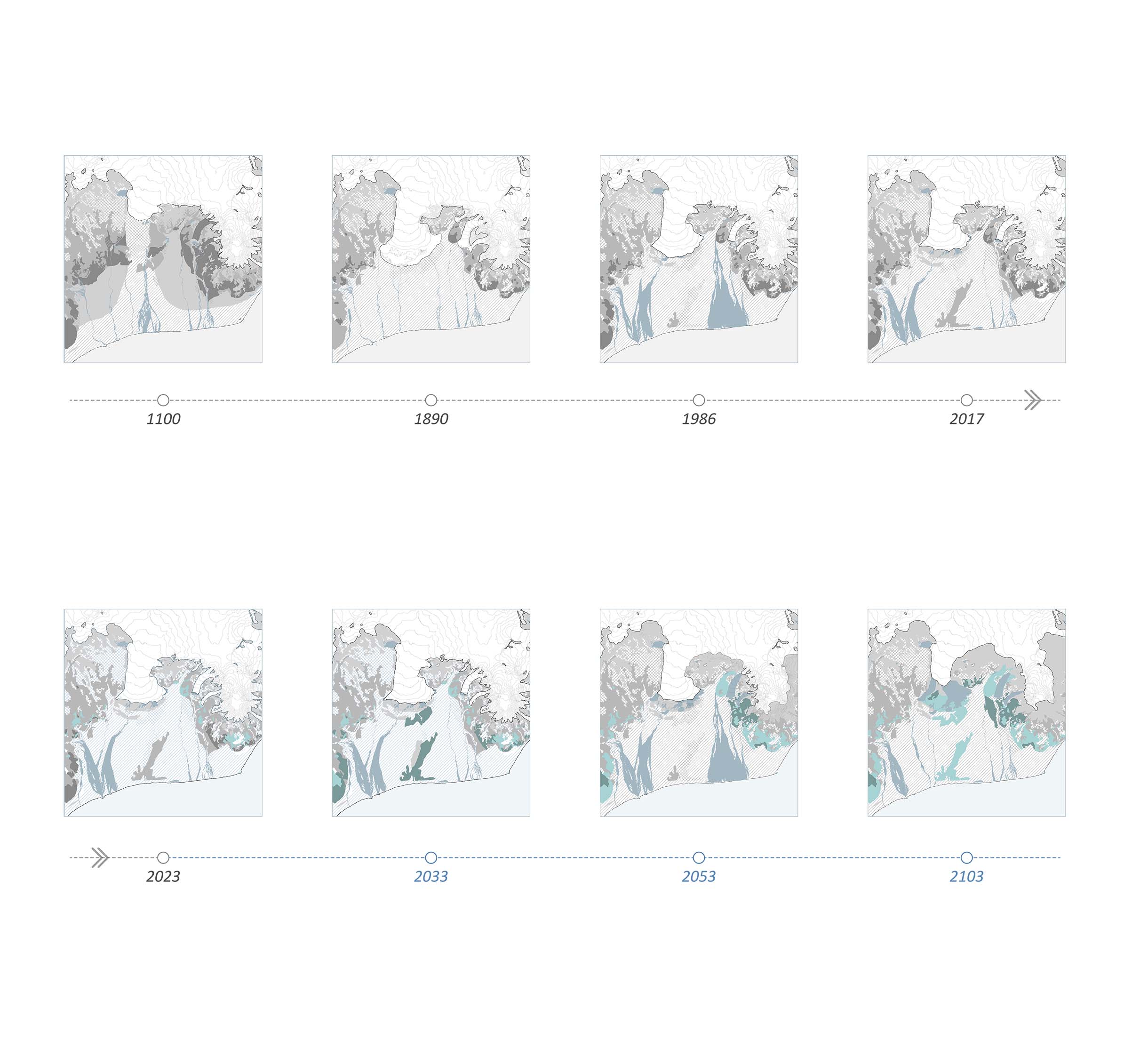
Not only the glacial landscape is vanishing, but also the natural disaster, glacial outburst flood, will disappear. The site is located in the junction between Gígjukvísl river and highway. The site could be understood as the only connection between human and nature along this barren floodplain. 

The design firstly creates an emergency design proposal dealing with the possible glacial outburst flood for human and more-than human in the “place of protection”. The design proposes several shelters using the materials from the remains of destroyed road. Also, it provides a safe space for flood observatory. The hiking trials are reorganised along the journey with several shelters. High terrain close to the river used to protect the bridge, while it is now preserving the ecological haven.

The post-glacial landscape park focuses on not only alleviating the side-effects of the disastrous glacial flood, but also the culture aspect. Several monuments and cultural elements, which together compose the place of memory, will be built based on the existing site condition. It is predictable that the site will face erosion and other challenges. The future destroyed bridge will be transformed to flood monuments. Other cultural interventions will be conducted in response to the challenges facing the Anthropocene.

Field Analysis: Skeiðarársandur

Skeiðarársandur could be understood as an unstable area because the water flows are happening frequently. Due to the melting of a few outlet glaciers, the energy is released through glacier outburst flood, either stably or unstably. The landscape is breathing; however, it is metabolising so fast that it has no time to recover. The energy flows are cutting the surface of landscape and destroying the new grown creatures and soils.


Field Drawing
The Past and Future of Skeiðarársandur

The formation of Vatnajökull starts about four thousand years ago. This process was accelerated during the little ice age and then, it is continuously retreating. However, the retreating speed of it is much higher than the formation process. All of the water will be released through erosion. The glaciers will retreat gradually while the glacier lagoon will become larger. In about 50 years, the whole outlet glacier will vanish leaving a barren canyon. 

Dynamic Flood Change
Dynamic Study of Glacial Outburst Flood

The drawing shows how the landscapes of different sites are affected by the glacial outburst flood during and after the jökulhlaups. It speculates the possible terrain changes based on previous dynamic system study. 

Dynamic Flood Change
Post-glacial Landscape Park

The post-glacial landscape park focuses on not only alleviating the side-effects of the disastrous glacial flood, but also the culture aspect. As the old highway is damaged by the flood, new routine for transportation across the skeidarasandur is proposed in the south side. The main pathway origins from the base of old highway.

Place of memory is composed of several monumnets and sanctuary for remembrance. They function as not only a memorial place, but also an educational area to help people understand the landscape, how it looks like in the past, how the landscape is formed. The main structure in place of protection is the flood observatory, which also functions as a shelter from the jökulhlaups.


The master plan of the park
Place of Memory

This area is the key area of the landscape park. It is located on the old Gígjukvísl bridge and highway. This area is composed of a series of monuments, which functions as not only a memorial place, but also an educational area to help people understand the landscape, how it looks like in the past, how the landscape is formed. 

Several old columns, which are the remains of the old bridge, constitutes the stone Gerðið monument. In Icelandic, the stone Gerðið is similar to the word “Stonehenge”. In the future, the memory of outlet glaciers and glacial outburst flood will be forgotten. When they see these huge concrete rocks, they could not understand these elements from the past civilisation. It is similar to how we see the Stonehenge in England – mysterious, marvellous and a little frightened. They will also want to figure out what the people in the past doing with these huge rocks. The monuments are, as a result, restoring the memory of the past and educates the people in the future.  

Detail Plan of the place of Memory
Section of the place of memory
The Columnar Sanctuary

It is an enclosed mediation space surrounded by the cracks of the abandoned bridge. The future generations could feel the power of the flood inside. Some plants could grow, which implicates that it is a safe place to stay. However, the past landscape is vanishing. 

The Columnar Sanctuary
Place of Protection

In the area of the place of protection in the park, not only the architecture works as a shelter, but the terrain also prevents the landscape behind this area. The place of protection is located in the north side of the park. It is the tips of the small hill, which was built to protect the highway. This area is composed of the pathway on the upper area and hiking trail in the lower area close to the river. The observatory is a steel structure connects two spaces. A steel bridge is linking the path to the observatory. 

Detail Plan of the place of protection
Shelter & Glacial Flood Observatory

Although the jökulhlaups is dangerous, the view of natural disaster is marvellous. Therefore, 

the project aims at creating a safe place viewing the jökulhlaups. As the highest point in Skeiðarársandur, it will become a centre observatory viewing the sublime view of Skeiðarárjökull among the large barren floodplain.

detail section of flood observatory
Student list
open list
close list