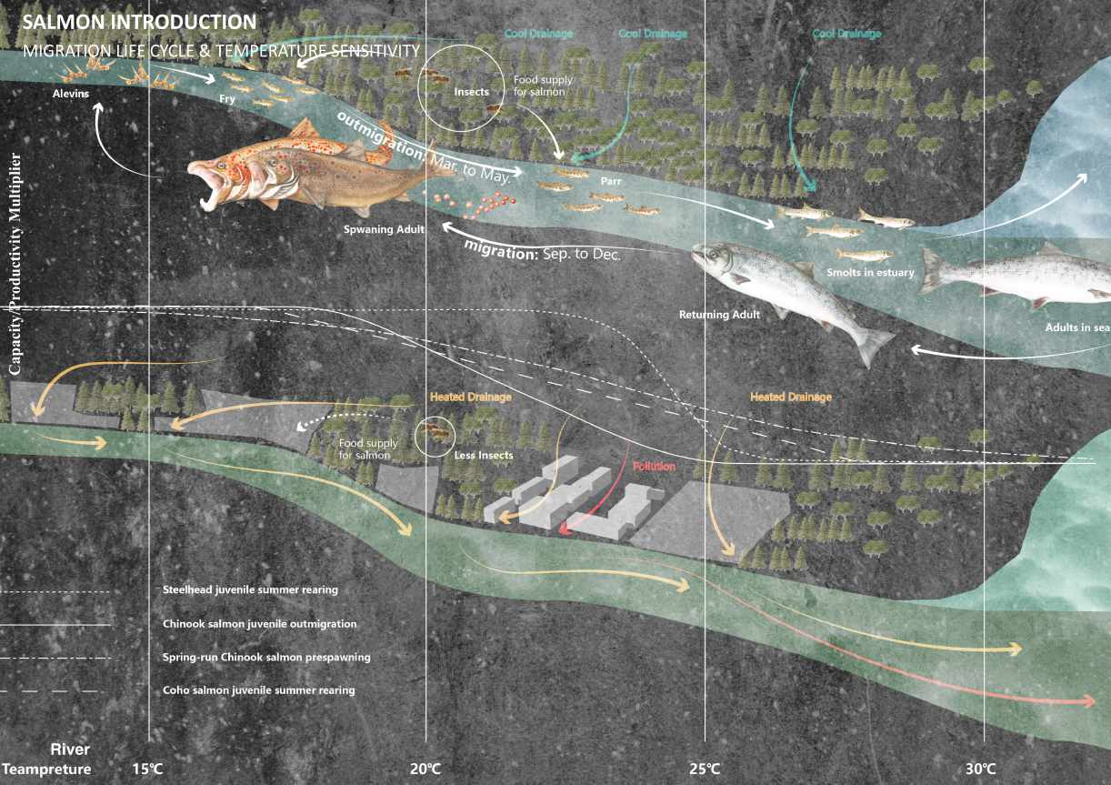
Design Context - Migration life cycle of salmon under pressure

Wild salmon have lived in the cold, pristine waters of the Pacific Ocean for thousands of years. All salmonids start as fertilized eggs, found in the gravelly areas of streams. As they swim out to sea as juveniles, they undergo substantial physiological changes and live in the ocean for many years, growing into a large pelagic adult. Once fully developed, the adult undergoes physiological changes, enabling them to move as spawners from salt water to fresh water, reaching their home streams or lakes. There, they will spawn and lay eggs for the next generation. Historically, Scotland has relied on salmon as a major economic source.

However, since the early 1970s, the number of salmon returning to Scotland's shores has declined dramatically as the migration life cycle means they face a range of threats and pressures in streams, rivers, and the high seas, including woodland degradation, flooding, and pollution. The River Dee, which has a large salmon population in Scotland, faces various issues affecting salmon habitat.

Salmon migration route acroos River Dee Basin
Wild salmon migration life cycle & temperature sensitivity
Project Statement

The challenges that our living environment is facing now are not only threatening humans but also more-than-human species. Those species other than humans are more easily influenced and hurt from my point of view. With a responsibility of protecting the landscape and more-than-human species, I am trying to use both the human and more-than-human perspectives as a tool to help create a better environment.

River species are influenced not only by in-stream factors but also by ecological and landscape processes occurring outside the river. I hope to intervene in the river's environment more holistically, influenced by landscape theory on reciprocity, to help salmon and other species live a better life in the river basin. Not only should I focus on the river, but also on the land and other things in the basin that are linked to it.

In my project, buffer strips, runoff holding ponds, and catchment ditches are used in terrestrial areas such as agricultural land, towns, and degraded forests to control runoff and thus indirectly benefit salmon habitat. In rivers directly associated with salmon, existing large woody debris from the river banks is used wherever possible. Fallen tree trunks, branches, and roots are collectively referred to as large woody debris. This heavy, semi-permanent material, made into wooden barriers for salmon, profoundly affects the morphology of the river by reducing or redirecting the flow of water.

Airview of habitats related to salmon
Zone one: Agricutural Land

Zone one is an area of high surface runoff and flooding, but there is a lot of agricultural land and little forest land in this area, so the main problem will be soil erosion, which will make forest regeneration difficult.

At first, the buffer stripes which use native scrubland and hedgerows will help reduce the soil erosion problem happened in agricultural land. After several years of working on the eroded soil, it is easier to make part of the buffer stripes into the native broadleaves which can help absorb the runoff pollution and improve the water quality.

Therefore, the wild salmon in the river will suffer less from the runoff pollution. As the time goes by, the seeding and saplings are growing into riparian forest, which can provide shade for the surface runoff, thus lowering the river temperature. In the end, the wild salmon can live in the river with a suitable temperature.

Zone One: Agrictural Land
Buffer stripes & Ditch in Zone One
Buffer stripes
ditch
Zone two: Urban Area

Zone two covers the town itself, and the surface water in this watershed flows through the town before entering the river dee. There are even more factories on the banks of the river dee, and even fossil fuel and gas storage facilities, so solving the problem of river pollution in this watershed is a major issue.

The riparian zone of urban area is covered with conifer trees which can affect the PH of the river, influencing the living habitat of wild salmon. So the first step is to retreat some of the conifer trees which are not so valuable. Then pile the cut conifers and use aquatic plants to slow and absorb the surface runoff from the urban areas as the runoff can cause serious pollution to the river, making harm to the salmon. With time going by, build up runoff holding ponds to further filter and absorb the surface runoff and seed the broadleaves to gradually establish the broadleaves forest.

Zone Two: Urban Area
Dynamic system in Zone Two
Zone Three: Degraded Woodland

Zone three is a relatively densely wooded area in the river dee, but it is also one of the most degraded areas of natural forest into planted coniferous forest. The site has the basic characteristics of a glacial landscape and the soil water storage capacity is decreasing from upland to the lowland. Therefore, at higher altitudes of the site, the slope is greater with low water storage capacity soil, making it more difficult to store water.

The high altitude of the site is prone to land degradation during the dry season due to insufficient rainfall. To solve this problem, water catchment ditches need to be established at high altitude to help store water and thus allow the saplings to endure during the dry season and gradually recover the forest.

I also choose to use large woody debris along the river to help the salmon directly. Fallen tree trunks, branches, and rootwads, collectively referred to as large woody debris, influence channel morphology and habitat for salmon. So I mainly designed three types of the wood barrier, digger log, deflector and shelter.


Zone Three: Degraded Woodland
Functions of Wood Barrier

Digger log is a tree trunk lodged across the stream channel in a manner simulating a fallen bankside tree. The log creates a low-stage dam, impounding water on the upstream side and creating a plunge pool on the downstream side from the erosive energy of water flowing over the log.

Deflectors are triangles of large wood filled with rocks, constructed against the bank with one side angled outward into the channel in the downstream direction. Deflectors redirect water flow toward the far bank, thereby narrowing the channel and encouraging the formation of meanders.

The main function of the pool which created by deflectors and digger logs is to provide space for salmon to hide and feed.

Shelter is the stacking of more stakes in the pool to give the salmon more hiding space, to provide shelter for the salmon to lay eggs and hatch eggs, and to provide shade and cooling water. The logs were made using nonnative Scottish pine trees felled in conifer wood.

Zone Three: Degraded Woodland
Salmon Perspective of Wood Barrier
Wood Barrier
Wood Barrier
Perspectives of Catchment Ditch & Wood Barrier in Zone Three
Wood Barrier
Water catchment ditch
Skills & Experience
  • Adobe Creative Suite
  • Rhino+Vray
  • AutoCAD
  • Sketchup
  • ArcGIS/QGIS
Student list
open list
close list