
The project aims to use water as a link between the human, social, and natural environment in the surrounding area of Tayport. Water, society, and ecology are the three main factors in designing the site. The foreshore, boundary, and back shore are all designed in response to changes in sea level rise, flooding, and biodiversity. The flood changes in the first 50 years occurred on the foreshore, and the damage caused by the flood was mitigated by working with the subsidence. As the sea level rise, the wetland farms began to play a role after 50 years to control surface runoff and flood risks, and the naturalized wetlands were fully mature. It takes time, and the plant growth of the first ten years makes it possible for the wetland to mature. Among them, the boundary of the salt marsh is a small scale(human scale), and the mode of experiential landscape allows people to strengthen their feelings about the natural changes of sea water, so that people can understand natural changes and respect nature. The mesoscale productive landscape (farmland) brings more possibilities for changes in the production structure to the people in the Tayport area.


Yuxi Peng


Project description


Tayport Intro
From the small town of Tayport all the way to the Tentsmuir Forest Reserve, you will pass through many different marine habitats. These habitats at the junction of land and sea are rich in natural activities, and the landscape experiences produced by different media are also different.
Tayport Area
Tayport is located near the mouth of the River Tay in northern Scotland. The surrounding texture mainly includes: the town of Tayport, the border of Saltmarsh and the Tentsmuir Forest Reserve. The rear is dominated by farmland.

Tayport Shore
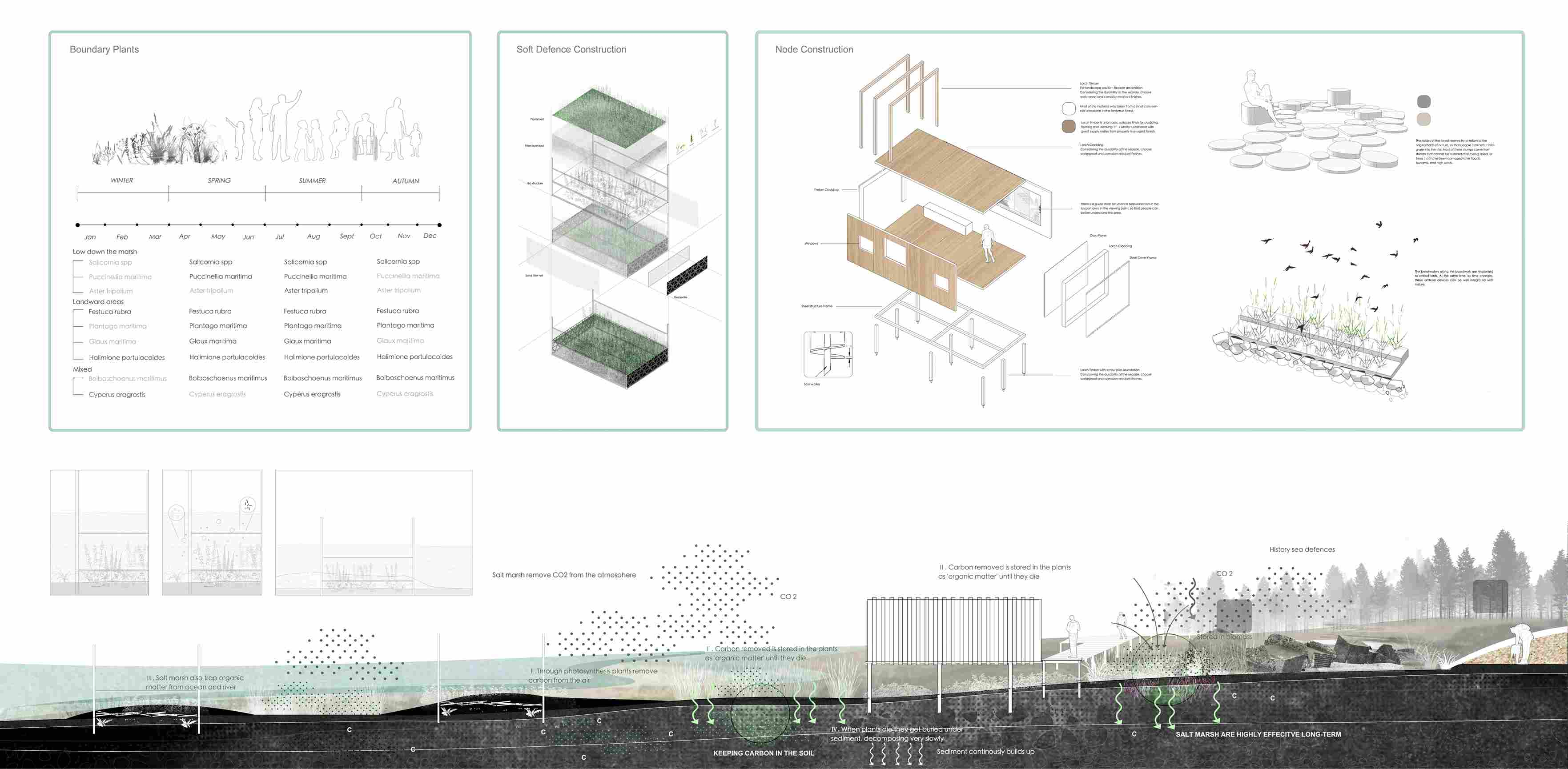
Like all estuaries, this area faces serious problems caused by sea-level rising. These include the degradation of intertidal zone, manifested in the reduction of mudflats and the reduction of salt marshes. At the same time, the terrain in this area is high in the west and low in the east, and the river water from the upper reaches gathers in this area, causing serious waterlogging problem. Therefore, above these problems, I will solve the problems from three parts: the foreshore mudflat and sandflat, the salt marsh boundary and the agricultural production of the back shore.

Tayport Strategies
The strategy starts with Tayport's coastal system. A buffer zone is designed in response to changes in the mudflats on the foreshore; the salt marsh area on the boundary is connected to the green space, expanding the area of the salt marsh; the coastal adaptive agricultural production landscape design is carried out on the back shore.

Master Plan and Overall Dynamic Change

Foreshore and Boundary
Soft defenses are set on the foreshore to deposit material, forming sand dunes of various sizes, creating new habitats and buffer areas.
Expand the boundaries of salt marshes, play the role of salt marshes in carbon control, and respond to climate change. At the same time, a landscape trail is created, and the landscape sites distributed along the coast are used to form a unique landscape experience in Tayport.

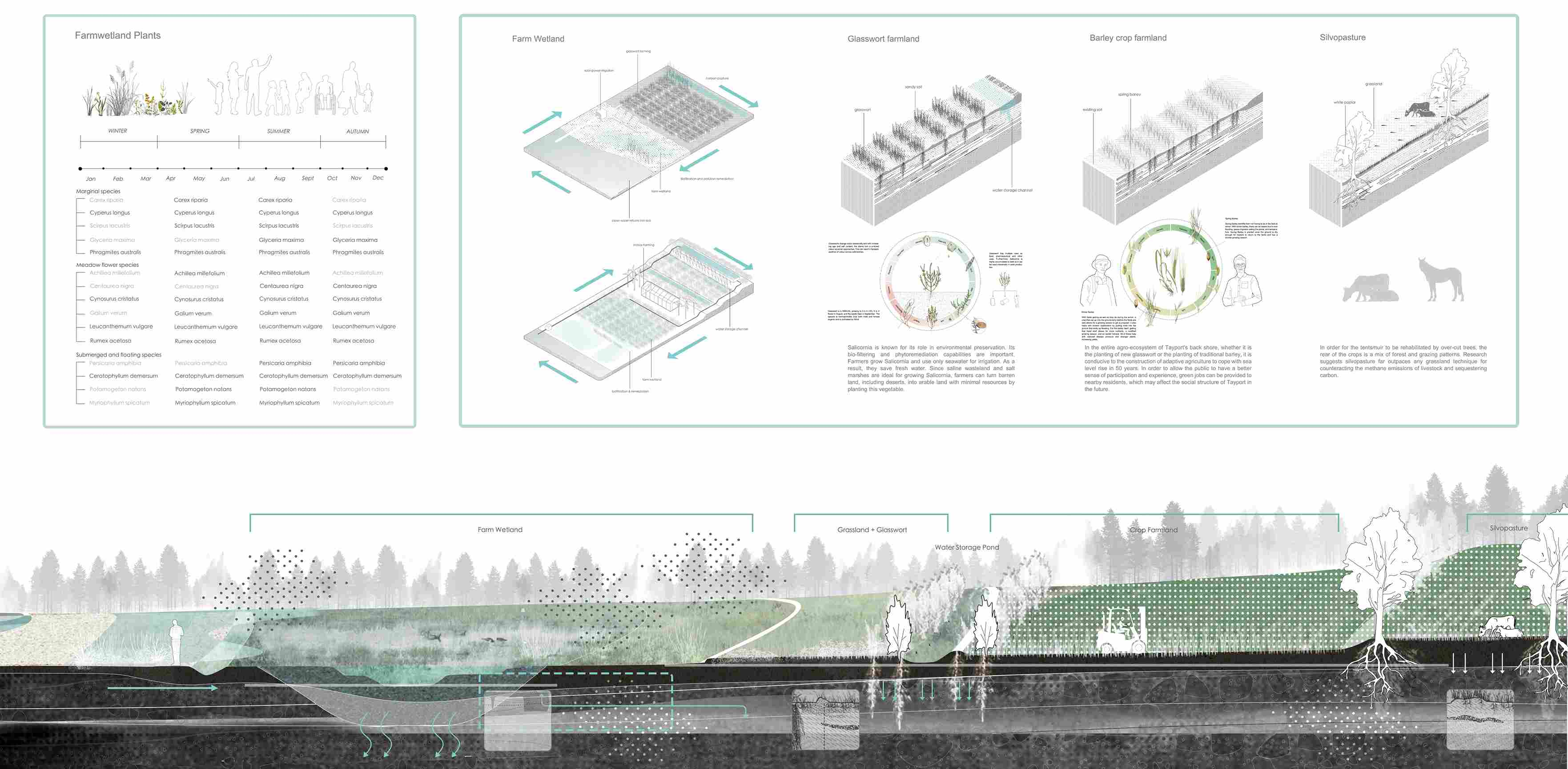
Back Shore
After 50-100 years, or even longer, the agricultural structure will change, and agricultural wetlands will appear, with adaptive coastal agriculture as the mainstay. Crop production will no longer be monotonous, but at the same time, it will have more functions of carbon sequestration and environmental protection. With the change of the agricultural structure on the back shore, the production structure of the small town of Tayport also changed accordingly.

Tayport Experience


Different Phases Dynamic Change


Yuxi Peng